We had originally planned to go chasing in June 2020, but the zombie apocalypse got in the way.
Fast forward three years and with the world returning to something like normal the Flying Cow chase team comprising of Duncan, Hans and myself met up in Denver, hired a car and hit the road.
We chased for two weeks in late May and early June.
At this time of the year, typically, storms are more prevalent in the northern states. Of course, it didn’t pan out that way.
For the previous month or so high pressure had been centered over Canada and the central northern states in the USA. This blocked weather pattern meant that for the entirety of our trip moisture was being dragged up from the Gulf of Mexico and into the southern states. The moisture was a very good thing as without it there are no storms but it did mean that we spent most of the time in the southern USA which involved driving some huge distances and we managed to cover over 4300 miles. What was lacking for much of time was good low level wind shear which is an important ingredient in creating Supercells (rotating thunderstorms) and this particularly affected us during the second weeks chasing.
Each chase day followed roughly the same pattern:
We would meet up in the morning and check out the Storm Prediction Centre (SPC) website 1, 2 and 3 day convective outlooks which would give us a general idea of where to chase (or whether to chase) that day and where to position ourselves for the following two days.
Next we checked the College of Du Page (COD) HRRR forecast. This is a computer generated simulation based on current weather data that predicts weather radar reflectivity. This turned out to be very useful and most of the time surprisingly accurate at narrowing down where and when storms were expected to initiate.
With the above information onboard we would travel to our favoured location and, as and when storms initiated, we would start the chase. Most chase days were long and we were often on the road until late in the evening.
During the chase itself we used the RadarScope app which displays real-time radar reflectivity data and location and also indicates hail, if a storm is rotating and any reports of wall or funnel clouds, which are often precursors to a tornado. RadarScope only displays major roads so to cover the smaller roads, which were often the ones we used to intercept, we used Maps.Me coupled with a mobile GPS unit.
Also used was a US SIM card so we could use a mobile phone as a Wi-Fi hotspot to provide data for the RadarScope app. The US mobile phone and road networks can be pretty sparse and lack of reception was a real issue at times - in future we will source a 4G/5G booster with an aerial to mitigate against this issue.
Dangers. There is no getting away from it but, enormous fun though it is, storm chasing can be risky and over the years there have been a number of chaser deaths and serious injuries. The principle hazards in order of likelihood are traffic, lightning, hail, wind gusts and a distant last, tornadoes.
From the moment we booked flights I tempered my expectations particularly after the last aborted trip and so far as I was concerned it was only after our plane took off the that I truly believed the trip was happening.
One of my favourite films is Twister. The movie recreates very well the excitement of the chase and there are tornadoes aplenty along with the odd flying cow (which is where our group got its name), but unfortunately real life is not like that. In reality, intercepting tornadoes is incredibly difficult as only around 10% of thunderstorms rotate and only about 10% of these generate a tornado, and if they are produced at all, they tend to be relatively small and are typically only on the ground for a few minutes. There are of course exceptions and these are the ones that make the headlines. With this in mind, it is important to be realistic about one’s chances and hope for some photogenic storms and lightning with anything else a big bonus.
For the first few days we didn’t stray that far from Colorado but did visit Wyoming, Nebraska and Kansas before heading south into New Mexico and Texas where we spent most of the time. We didn’t chase every day and managed to visit a few parks and monuments.
I am not going to write much about the places we visited and just let the pictures and videos, which are in date order, speak for themselves. The exception to this is the account below of our chase on Friday 2nd June 23.
Greeley, Colorado
Albin, Wyoming
Somewhere in Wyoming
It wasn't all chasing. This was taken at the Scotts Bluff National Monument in Nebraska
Typical chase scene somewhere in Kansas with Hans driving and me navigating in the back using RadarScope
This was taken either in southern Colorado or northern Texas
The storm chase this day was exhilarating and not a little scary at times.
Storms were forecast to initiate mid-afternoon. The COD HRRR simulation suggested cells going up both north and south of us. There was an enhanced threat though with modest shear (as it has been all trip) but this time with good veering with altitude.
We spent a good few hours in the Odessa (Texas) area waiting to see what eventuated.
Eventually, cells did indeed initiate in the forecast areas and then it was decision time.
The cells to the north looked good but were about a 2-hour drive whereas a cell to the south didn’t look quite so good but was only an hour or so’s drive a way. It really was a 50 - 50 decision and in the end we elected to go south.
It is all part of the learning experience, but the problem we found with going south is that, in terms of tornadoes, it puts you on the wrong side of the storm system, and so it proved.
In the meantime, the northern cell became severe warned and generated a tornado. This left me very frustrated as once again we appeared to have picked the wrong system, but we were committed by this stage.
The road system is very sparse in southern Texas and getting to the south side of the storm (where most tornadoes tend to form) was going to involve a very long detour so we decided to core punch (if that’s the correct term). The reported hail size was around 0.75 inch so we thought it was worth the risk, not least as we would only be going round the edge of the hail core. In end it wasn’t too bad with only small hail and some heavy bursts of rain. Due to the shape of the storm we had to core punch twice!
We finally got to the other side of the storm and got to see some strong rotation and wall cloud, but nothing dropped.
Fort Stockton, Texas - this message cam with an eerie, unsettling alarm, which I guess is sort of the point
Fort Stockton, Texas - this is the storm mentioned above
Some very interesting movement on this cell. An SPC tornado report was logged around this time at this location, so we might not have been too far off. Moments after I shot this footage very large hail started falling and we had to make a quick getaway! This is the cell that we had to core punch twice to get on the south side.
By this time it was around 6pm and we were nearing the end of the chase. We had been keeping an eye on a cell a little way to the south and noticed that it had massively intensified in only a few minutes and was also rotating.
Trouble was that, once again, getting to the south side of the storm would have involved a long detour. There was however a much more direct route but that involved going perilously close to the core which at this stage had monster 2.75 inch hail. I was well aware of the SPC long range forecast which indicated there was little chance of severe tornadic storms before our holiday finished. With this in mind, we decided to chance it and core punched the storm.
The journey through the storm was hazardous to say the least and we experienced some pretty significant hail, though fortunately not as large as it could have been.
Punching through the core and into clean air gave us a huge adrenaline rush and was also a huge relief. I wouldn’t recommend doing what we did, but am still glad we did it. The car had a few small dents so would probably disagree.
It was a risky move, but this put us in perfect position for an intercept. To be honest, I had always assumed we wouldn’t see a tornado on this trip but within a few minutes we spotted an obvious wall cloud accompanied by an inflow jet that was moving at a tremendous pace. By this stage there were also plenty of other chasers around who were way more experienced than us so and for the first time I started to think the unthinkable.
We pulled up and watched the wall cloud. Within a minute or two we spotted dust getting stirred up under the wall cloud and seconds later, and to my utter astonishment, we had a full on tornado, and a decent size one at that.
Well bugger me....somewhere in Texas very close to the border with Mexico
We stood and watched for about 10 minutes. During this time we had a crazy amount of lightning which was landing all around us. We were standing by a barbed wire fence which probably wasn’t the best idea and I felt a small tingle in my finger after one strike. Just after this very large hail started to fall with one piece hitting me on the foot which really hurt - I still had a big red spot there two days later. Duncan also got hit on the head!
Mesmerising as the tornado was, we ran for the car and got out of there real quick. We stopped several times to view the storm but each time the hail quickly caught up with us and in any case the tornado eventually became rain wrapped.
As the tornado matured it took on more of a stovepipe shape.
This is one of my last shots before the tornado became rain wrapped and the hail came to get us (again)
We intercepted the tornado very close to the Mexican border near Paynes Corner in Texas.
We stopped for dinner at a nearby village called Comstock.
Other than dinner and some friendly locals, we were treated to a stunning lightning display and also the heaviest rain I have ever experienced, although, for me anyway, this paled into insignificance compared to the tornado.
This is some slow motion footage shot by Duncan while we were having dinner in Comstock
We chased on and off for another week after the tornado and also did a few more conventional touristy type things.
On the way to Del Rio in Texas
At the Mexican border in Del Rio
The Flying Cow chase team
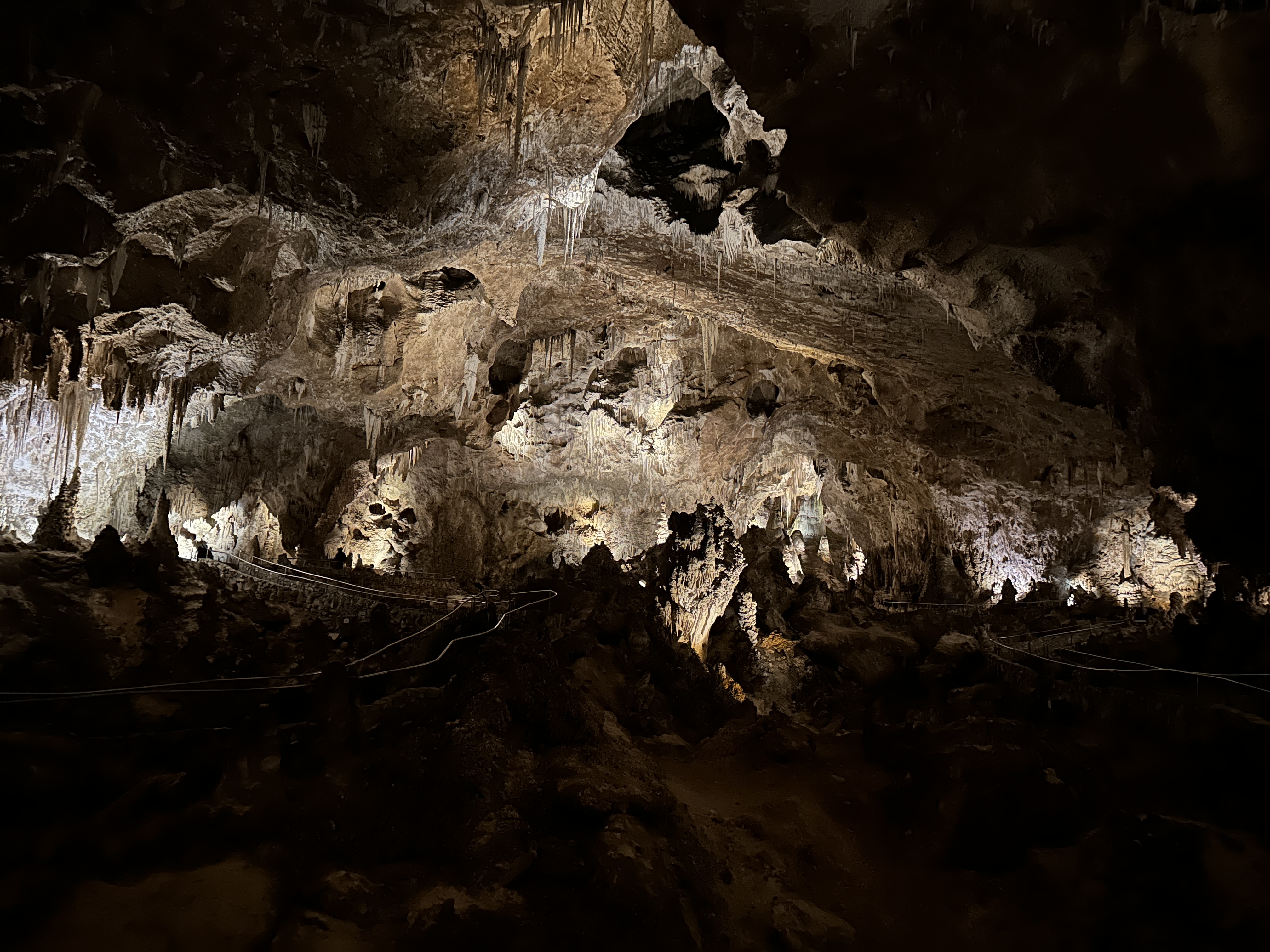
We also visited the Carlsbad Caverns in New Mexico, which we renamed the Carlsberg Caverns - see the various random shots below. The caves were really quite something, although this doesn't really come across in the pictures. It was a steep one and a half mile walk to the bottom with another couple of miles of pathways from there to explore. All in all, we spent over 5 hours down there admiring the scenery and luxuriating in the cool air before ascending to the surface in an elevator of all things.
Datil, New Mexico. This was only a Marginal chase day but we chased regardless and were rewarded with a lovely little supercell. Alas, as soon as it hit some cooler air the storm circulation quickly subsided.
Datil, New Mexico. A nice little time-lapse this one. It would have been even nicer if I had set the camera level! The next day also had a Marginal SPC forecast but in stark contrast produced bugger all.
On our final chase day we were conscious of the need to not stray too far, so set off on a half hearted chase then headed off back to Denver.
On the way back we spotted a nearby cell which had a wall cloud notification. RadarScope showed zero rotation, but we gave chase anyway.
We didn’t see any wall cloud but the storm produced lots of lightning and we managed to bag a few good shots, which was a nice way to end the trip.
Somewhere in Colorado
The final shot of the trip